The union territory of Goa Daman & Diu was liberated from Portuguese rule in the year 1961, the territory had about 7460 ha. of land under irrigation. Owing to the undulating topography of the district of Goa and consequent limited availability of cultivable area, need was felt for ensuring maximum production of food grains from optional available area. Realizing this need, the territory embarked upon an extensive program of irrigation.
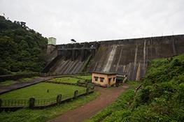
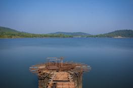
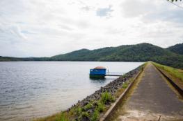
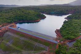
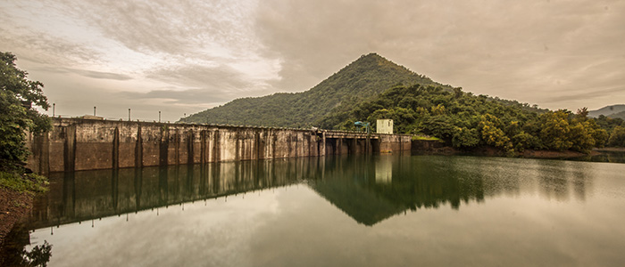
The Anjunem Irrigation Project is located on Costi nadi at Anjunem village in Sattari Taluka of North Goa District, a tributary of Valvanti River under Madei Basin. The dam is located between 15 36'57" to 15 33'30" latitude and 74 5'22" to 73 58'30" longitude. The project envisages construction of:
- Gravity Masonry Dam
- Pick up Weir
- Two canals, one on the right bank and one on the left bank
The Anjunem Irrigation Project is a medium irrigation project completed in 1989 and the full ultimate potential of 4600 Ha (2100 Ha CCA) has already been created of which 1415 Ha (CCA) is under utilization. Since the project is situated in high rain-fed areas of the Western Ghats which is prone to fast vegetation and weed growth, roots of these vegetation enter the canal lining and damage the concrete lining. Repairs and renovation of the existing canals were planned in 2 phases during the years 2006-07 and 2007- 08. Accordingly, 14.05 Kms length of canal has been renovated in the 1st phase. The 2nd phase of renovation works in a length of 15.58 Kms of the lining of the main canals was completed during 2007-08. The Dam Safety Panel has suggested atomization of the gates (which is being planned) and replacement of the apron (which is in progress).
LOCATION
- State:Goa
- Taluka:Sattari
- River:Oluleni (Costi Nadi)
- Site of Dam:150-368’-57 Latitude 740-5’22 Longitude
HYDROLOGY
- Drainage area upto Dam site:17.18 KM2 (6.63 sq.miles)
- Average monsoon rainfall:3730 MM (147 2")
- Maximum monsoon rainfall:5358 MM (211 6")
- Minimum monsoon rainfall:2369 MM (93.4")
- Maximum Observed flood:42.33 Cum/sec (01496 cusec)
- Maximum Design flood:17000 cusecs
- Routed discharge:17,000 cusecs
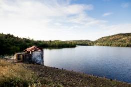
RESERVOIR
- Deepest Bed Level:RL 53.4M (175.0 ft)
- Dead Storage Level:RL 61.5 M (202 ft)
- Maximum Water Level:RL 93.2 M (305.7 ft)
- Full Reservoir Level:RL 93.2 M (305.7 ft)
- Capacity D.S.L.:62.3 Hec. M(510.2 Acre ft)
- Capacity at F.R.L:FRL 4483 Hec.M (36760 Acre ft)
- Area of submergence at FRL:253 Hec. (623 acres)
- Area of submergence at DSL:16 Hec. (39.5 acre)
- Annual evaporation losses:212 mm (84")
DAM
- Type of dam:Straight gravity masonry Dam
- Total length of dam:176.00 m. (577.28 ft)
- Maximum height above the deepest bed level:42.8 m. (140 ft)
- Top of dam:R.L. 96.2 m. (315.5 ft)
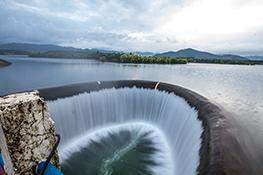
SPILLWAY
- Length of spillway:39.48 m (129.5 ft)
- Elevation of spillway crest:R.L. 86.90 m. (285 ft)
- Type of crest gates:Radial
- Size of gates:7.62 x 6.85 (25’ x 22’)
- No. of gates:4 Nos.
- Type of energy dessipator:Flip hucket
- Flip angle:45 degrees
- Front batter:0.85 to 1
- Back batter:1 to 8
MASONRY
- Length of transition (Right):51.57 M
- Length of transition (Left):84.95 M
- Front batter:0.75 to 1
- Back batter:1 to 15
IRRIGATION
- Gross Command Area:2624 ha. (6481 Acres)
- Irrigation Area:2100 ha. (5187 Acres)
- Annual Irrigation:4620 ha. (11411 Acres)
- Crop Pattern:
Kharif- Paddy - 55%
- Sugarcane - 35%
- Garden crops - 5%
- Vegetables - 5%
- Paddy - 50%
- Vegetables - 10%
- Vegetable - 20%
- Pulses - 40%